IMAGES TAKEN NEAR TO
Manor Drive, MILTON KEYNES, MK19 7AL
Introduction
This page details the photographs taken nearby to Manor Drive, MK19 7AL by members of the Geograph project.
The Geograph project started in 2005 with the aim of publishing, organising and preserving representative images for every square kilometre of Great Britain, Ireland and the Isle of Man.

There are currently over 7.5m images from over14,400 individuals and you can help contribute to the project by visiting https://www.geograph.org.uk
Image Map
Images are licensed for reuse under creativecommons.org/licenses/by-sa/2.0
Notes
- Clicking on the map will re-center to the selected point.
- The higher the marker number, the further away the image location is from the centre of the postcode.
Image Listing (8 Images Found)
Images are licensed for reuse under creativecommons.org/licenses/by-sa/2.0
Image
Details
Distance
1
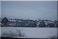
Wolverton Road, Haversham
Looking more like a slice of outer London suburbia than a Buckinghamshire village, this is the 'new' part of Haversham physically separate from the older part of the village. Much of the housing here predates the creation of Milton Keynes but does reflect the development of nearby Wolverton as an industrial centre. There is a line of 1930s style semi-detached houses on the right; Brookfield Road leads off at the mini-roundabout to the left.
Image: © Stephen McKay
Taken: 23 Oct 2020
0.08 miles
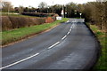
2
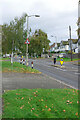
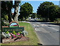
Entering Haversham
There are two distinct parts to Haversham: the old village around the church and 'New' Haversham seen here with relatively new houses and a more suburban feel. The sign features St Mary's Church and the railway viaduct over the River Great Ouse.
Image: © Stephen McKay
Taken: 23 Oct 2020
0.15 miles
3
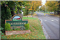
Haversham Road in the village of Haversham
Image: © Mat Fascione
Taken: 8 Aug 2015
0.17 miles