IMAGES TAKEN NEAR TO
Northampton Road, MILTON KEYNES, MK19 6NR
Introduction
This page details the photographs taken nearby to Northampton Road, MK19 6NR by members of the Geograph project.
The Geograph project started in 2005 with the aim of publishing, organising and preserving representative images for every square kilometre of Great Britain, Ireland and the Isle of Man.

There are currently over 7.5m images from over14,400 individuals and you can help contribute to the project by visiting https://www.geograph.org.uk
Image Map
Images are licensed for reuse under creativecommons.org/licenses/by-sa/2.0
Notes
- Clicking on the map will re-center to the selected point.
- The higher the marker number, the further away the image location is from the centre of the postcode.
Image Listing (10 Images Found)
Images are licensed for reuse under creativecommons.org/licenses/by-sa/2.0
Image
Details
Distance
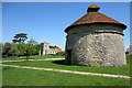
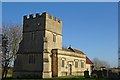
2
Dovecote & Church at Furtho, Northamptonshire
Image: © John Jenkins
Taken: Unknown
0.01 miles
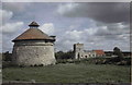
4
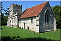
St Bartholomew's Church, Furtho
This church is unused and has been out of regular use since 1921
Image: © Philip Jeffrey
Taken: 25 May 2012
0.06 miles
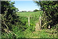
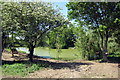
6
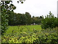
Animals grazing by the wood on Manor Farm
Image: © Phil Catterall
Taken: 6 Oct 2006
0.08 miles
8
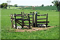
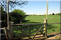
Gate on the Grafton Way
Though there is only a vestigial fence these days
Image: © Philip Jeffrey
Taken: 25 May 2012
0.11 miles