IMAGES TAKEN NEAR TO
Ridgmont, MILTON KEYNES, MK19 6JQ
Introduction
This page details the photographs taken nearby to Ridgmont, MK19 6JQ by members of the Geograph project.
The Geograph project started in 2005 with the aim of publishing, organising and preserving representative images for every square kilometre of Great Britain, Ireland and the Isle of Man.

There are currently over 7.5m images from over14,400 individuals and you can help contribute to the project by visiting https://www.geograph.org.uk
Image Map
Images are licensed for reuse under creativecommons.org/licenses/by-sa/2.0
Notes
- Clicking on the map will re-center to the selected point.
- The higher the marker number, the further away the image location is from the centre of the postcode.
Image Listing (8 Images Found)
Images are licensed for reuse under creativecommons.org/licenses/by-sa/2.0
Image
Details
Distance
1
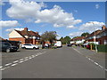
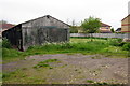
Ridgmont, Deanshanger
Leading onto North Way.
Image: © JThomas
Taken: 17 Aug 2019
0.06 miles
5
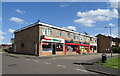
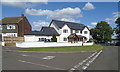
Scout Hut
2nd Deanshanger Scout Group Jubilee Hall
Image: © Philip Jeffrey
Taken: 19 May 2012
0.22 miles
8
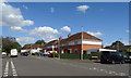
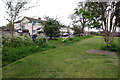
Sports ground and children's playground at Deanshanger
Image: © Phil Catterall
Taken: 6 Oct 2006
0.23 miles