IMAGES TAKEN NEAR TO
Upper Weald, MILTON KEYNES, MK19 6EL
Introduction
This page details the photographs taken nearby to Upper Weald, MK19 6EL by members of the Geograph project.
The Geograph project started in 2005 with the aim of publishing, organising and preserving representative images for every square kilometre of Great Britain, Ireland and the Isle of Man.

There are currently over 7.5m images from over14,400 individuals and you can help contribute to the project by visiting https://www.geograph.org.uk
Image Map
Images are licensed for reuse under creativecommons.org/licenses/by-sa/2.0
Notes
- Clicking on the map will re-center to the selected point.
- The higher the marker number, the further away the image location is from the centre of the postcode.
Image Listing (7 Images Found)
Images are licensed for reuse under creativecommons.org/licenses/by-sa/2.0
Image
Details
Distance
2
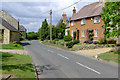
Cute Cottage
A rather fetching little cottage on the Calverton Road, in Upper Weald.
Image: © Mr Biz
Taken: 25 Jul 2006
0.05 miles
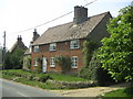
3
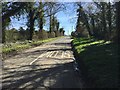
Upper Weald
Upper Weald, approached from the North.
Image: © Richard Schmidt
Taken: 29 Mar 2007
0.06 miles
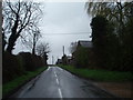
5
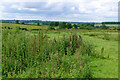
Open fields around Upper Weald, Calverton
Image: © Cameraman
Taken: 23 Jun 2011
0.10 miles
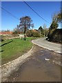
7
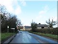
Entrance to Calverton or is it Upper Weald
Image: © Alex McGregor
Taken: 11 Feb 2014
0.11 miles