IMAGES TAKEN NEAR TO
Calverton, MILTON KEYNES, MK19 6ED
Introduction
This page details the photographs taken nearby to MK19 6ED by members of the Geograph project.
The Geograph project started in 2005 with the aim of publishing, organising and preserving representative images for every square kilometre of Great Britain, Ireland and the Isle of Man.

There are currently over 7.5m images from over14,400 individuals and you can help contribute to the project by visiting https://www.geograph.org.uk
Image Map
Images are licensed for reuse under creativecommons.org/licenses/by-sa/2.0
Notes
- Clicking on the map will re-center to the selected point.
- The higher the marker number, the further away the image location is from the centre of the postcode.
Image Listing (33 Images Found)
Images are licensed for reuse under creativecommons.org/licenses/by-sa/2.0
Image
Details
Distance
1
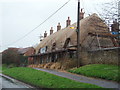
Thatched House
A freshly thatched house in Calverton.
Image: © Richard Schmidt
Taken: 29 Mar 2007
0.01 miles
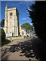
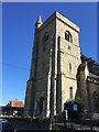
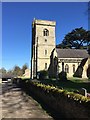
5
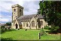
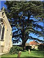
All Saints Church, Lower Weald, Calverton, Bucks
Image: © Cameraman
Taken: 23 Jun 2011
0.06 miles
8
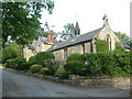
The Old Schoolhouse, Calverton
This was once a former school house in Calverton.
Image: © Mr Biz
Taken: 9 May 2009
0.07 miles
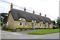
9
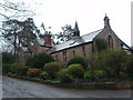
Converted School House
A house converted from a former school house in Calverton.
Image: © Richard Schmidt
Taken: 29 Mar 2007
0.07 miles