IMAGES TAKEN NEAR TO
Nash Road, MILTON KEYNES, MK19 6EA
Introduction
This page details the photographs taken nearby to Nash Road, MK19 6EA by members of the Geograph project.
The Geograph project started in 2005 with the aim of publishing, organising and preserving representative images for every square kilometre of Great Britain, Ireland and the Isle of Man.

There are currently over 7.5m images from over14,400 individuals and you can help contribute to the project by visiting https://www.geograph.org.uk
Image Map
Images are licensed for reuse under creativecommons.org/licenses/by-sa/2.0
Notes
- Clicking on the map will re-center to the selected point.
- The higher the marker number, the further away the image location is from the centre of the postcode.
Image Listing (10 Images Found)
Images are licensed for reuse under creativecommons.org/licenses/by-sa/2.0
Image
Details
Distance
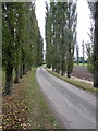
1
Beachampton Business Park
The entrance to Beachampton Business Park, formerly Potash Farm, near Beachampton.
Image: © Richard Schmidt
Taken: 29 Mar 2007
0.07 miles
3
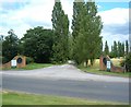
Potash Farm Business Park
The entrance to the Business Park located between Nash and Beachampton.
Image: © Mr Biz
Taken: 13 Jul 2008
0.14 miles
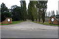
4

The entrance to Beachampton Business Park
Image: © David Howard
Taken: 28 Dec 2019
0.15 miles
5
The entrance to Beachampton Business Park
Image: © David Howard
Taken: 28 Dec 2019
0.16 miles
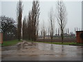
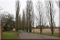
6
Entrance to Beachampton Business Park
Image: © Philip Jeffrey
Taken: 11 Oct 2012
0.16 miles
7
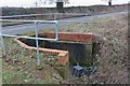
Drainage channel going under Stratford Road, Beachampton
Image: © David Howard
Taken: 28 Dec 2019
0.16 miles