IMAGES TAKEN NEAR TO
Watery Lane, MILTON KEYNES, MK19 6DZ
Introduction
This page details the photographs taken nearby to Watery Lane, MK19 6DZ by members of the Geograph project.
The Geograph project started in 2005 with the aim of publishing, organising and preserving representative images for every square kilometre of Great Britain, Ireland and the Isle of Man.

There are currently over 7.5m images from over14,400 individuals and you can help contribute to the project by visiting https://www.geograph.org.uk
Image Map
Images are licensed for reuse under creativecommons.org/licenses/by-sa/2.0
Notes
- Clicking on the map will re-center to the selected point.
- The higher the marker number, the further away the image location is from the centre of the postcode.
Image Listing (25 Images Found)
Images are licensed for reuse under creativecommons.org/licenses/by-sa/2.0
Image
Details
Distance
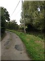
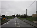
1

Watery Lane at the junction of Stratford Road
Image: © David Howard
Taken: 27 Jun 2020
0.03 miles
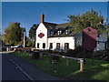
4
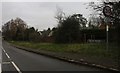
Stratford Road, Beachampton
The speed limit was recently reduced from 40mph to 30
Image: © David Howard
Taken: 28 Dec 2019
0.04 miles
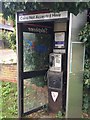
5
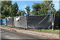
Can you tell what it is yet?
Something will no doubt be unveiled here, but as it's the village green I can only think of some sort of monument.
Image: © David Howard
Taken: 27 Jun 2020
0.05 miles
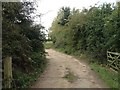
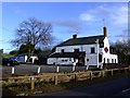
7

The Bell Inn, Beachampton
Good Beer Guide pub and restaurant with accommodation available.
Image: © Mr Biz
Taken: 13 Jul 2008
0.06 miles