IMAGES TAKEN NEAR TO
Main Street, MILTON KEYNES, MK19 6DX
Introduction
This page details the photographs taken nearby to Main Street, MK19 6DX by members of the Geograph project.
The Geograph project started in 2005 with the aim of publishing, organising and preserving representative images for every square kilometre of Great Britain, Ireland and the Isle of Man.

There are currently over 7.5m images from over14,400 individuals and you can help contribute to the project by visiting https://www.geograph.org.uk
Image Map
Images are licensed for reuse under creativecommons.org/licenses/by-sa/2.0
Notes
- Clicking on the map will re-center to the selected point.
- The higher the marker number, the further away the image location is from the centre of the postcode.
Image Listing (31 Images Found)
Images are licensed for reuse under creativecommons.org/licenses/by-sa/2.0
Image
Details
Distance
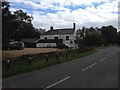
2
Main Street, Beachampton
Looking towards the Mowgli Indian Restaurant
Image: © David Howard
Taken: 27 Jun 2020
0.01 miles
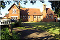
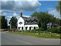
5
The Mowgli Indian Restaurant, Beachampton
This was the Bell Inn till about 10 years ago.
Image: © David Howard
Taken: 27 Jun 2020
0.03 miles
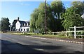
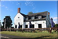
10
The Bell Inn, Beachampton
Good Beer Guide pub and restaurant with accommodation available.
Image: © Mr Biz
Taken: 13 Jul 2008
0.07 miles