IMAGES TAKEN NEAR TO
Beachampton, MILTON KEYNES, MK19 6DS
Introduction
This page details the photographs taken nearby to MK19 6DS by members of the Geograph project.
The Geograph project started in 2005 with the aim of publishing, organising and preserving representative images for every square kilometre of Great Britain, Ireland and the Isle of Man.

There are currently over 7.5m images from over14,400 individuals and you can help contribute to the project by visiting https://www.geograph.org.uk
Image Map
Images are licensed for reuse under creativecommons.org/licenses/by-sa/2.0
Notes
- Clicking on the map will re-center to the selected point.
- The higher the marker number, the further away the image location is from the centre of the postcode.
Image Listing (10 Images Found)
Images are licensed for reuse under creativecommons.org/licenses/by-sa/2.0
Image
Details
Distance

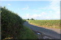
2
Entrance to Mill Farm Courtyard
Converted to a business park, Mill Farm is located between Calverton and Beachampton
Image: © Mr Biz
Taken: 9 May 2009
0.09 miles
5
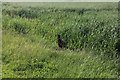
Pheasant by Mill Farm, Beachampton
He was quite prepared to stand there and talk to me, and was not the slightest way inclined to fly off.
Image: © David Howard
Taken: 27 Jun 2020
0.12 miles
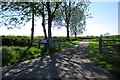
9

A Gap in the Hedge
Through the gap in the hedge along the road from Beachampton to Calverton can be seen a ploughed field and a telegraph pole.
Image: © Richard Schmidt
Taken: 29 Mar 2007
0.16 miles