IMAGES TAKEN NEAR TO
Deanshanger Road, MILTON KEYNES, MK19 6BS
Introduction
This page details the photographs taken nearby to Deanshanger Road, MK19 6BS by members of the Geograph project.
The Geograph project started in 2005 with the aim of publishing, organising and preserving representative images for every square kilometre of Great Britain, Ireland and the Isle of Man.

There are currently over 7.5m images from over14,400 individuals and you can help contribute to the project by visiting https://www.geograph.org.uk
Image Map
Images are licensed for reuse under creativecommons.org/licenses/by-sa/2.0
Notes
- Clicking on the map will re-center to the selected point.
- The higher the marker number, the further away the image location is from the centre of the postcode.
Image Listing (17 Images Found)
Images are licensed for reuse under creativecommons.org/licenses/by-sa/2.0
Image
Details
Distance
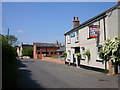
2
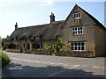
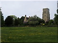
Wicken
Cottages in the south east of the village.
Image: © Ian Rob
Taken: 2 Jun 2007
0.14 miles
4
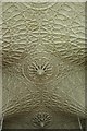
St John the Evangelist, Wicken, Northants - Ceiling
Image: © John Salmon
Taken: 21 Jul 2001
0.17 miles
5
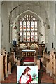
St John the Evangelist, Wicken, Northants - East end
Image: © John Salmon
Taken: 21 Jul 2001
0.17 miles
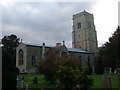
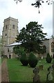
6
St John's Church
St John's Church Wicken
Image: © Shaun Ferguson
Taken: 21 May 2010
0.17 miles
7
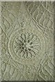
St John the Evangelist, Wicken, Northants - Ceiling
Image: © John Salmon
Taken: 21 Jul 2001
0.18 miles
8
St John the Evangelist, Wicken, Northants
Image: © John Salmon
Taken: 21 Jul 2001
0.18 miles
9
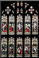
St John the Evangelist, Wicken, Northants - Window
Image: © John Salmon
Taken: 21 Jul 2001
0.18 miles
10
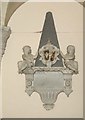
St John the Evangelist, Wicken, Northants - Wall monument
Image: © John Salmon
Taken: 21 Jul 2001
0.18 miles