IMAGES TAKEN NEAR TO
Whittlebury Road, MILTON KEYNES, MK19 6BJ
Introduction
This page details the photographs taken nearby to Whittlebury Road, MK19 6BJ by members of the Geograph project.
The Geograph project started in 2005 with the aim of publishing, organising and preserving representative images for every square kilometre of Great Britain, Ireland and the Isle of Man.

There are currently over 7.5m images from over14,400 individuals and you can help contribute to the project by visiting https://www.geograph.org.uk
Image Map
Images are licensed for reuse under creativecommons.org/licenses/by-sa/2.0
Notes
- Clicking on the map will re-center to the selected point.
- The higher the marker number, the further away the image location is from the centre of the postcode.
Image Listing (12 Images Found)
Images are licensed for reuse under creativecommons.org/licenses/by-sa/2.0
Image
Details
Distance
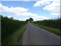
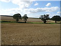
2
Bend in the minor road towards Deanshanger
Passing the entrance to Old Copse Farm.
Image: © JThomas
Taken: 17 Aug 2019
0.03 miles
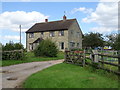
3
Deanshanger
Derelict and somewhat overgrown Farmhouse.
Image: © Ian Rob
Taken: 2 Jun 2007
0.04 miles
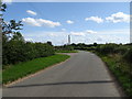
5
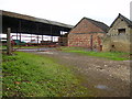
Redundant farm buildings north west of Deanshanger
Image: © Phil Catterall
Taken: 6 Oct 2006
0.08 miles
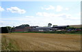
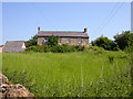
8
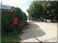
Entrance to Hurst Farm, Wicken
Off Whittlebury Road.
Showing position of Postbox No. MK19 131.
See Image] for postbox.
Image: © JThomas
Taken: 17 Aug 2019
0.15 miles
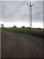
9
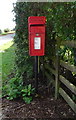
Elizabeth II postbox on Whittlebury Road
Postbox No. MK19 131.
See Image] for context.
Image: © JThomas
Taken: 17 Aug 2019
0.16 miles