IMAGES TAKEN NEAR TO
Badgers Way, BUCKINGHAM, MK18 7HL
Introduction
This page details the photographs taken nearby to Badgers Way, MK18 7HL by members of the Geograph project.
The Geograph project started in 2005 with the aim of publishing, organising and preserving representative images for every square kilometre of Great Britain, Ireland and the Isle of Man.

There are currently over 7.5m images from over14,400 individuals and you can help contribute to the project by visiting https://www.geograph.org.uk
Image Map
Images are licensed for reuse under creativecommons.org/licenses/by-sa/2.0
Notes
- Clicking on the map will re-center to the selected point.
- The higher the marker number, the further away the image location is from the centre of the postcode.
Image Listing (28 Images Found)
Images are licensed for reuse under creativecommons.org/licenses/by-sa/2.0
Image
Details
Distance
1
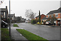
Badgers Way
The principal road through the Badgers Estate, viewed during rain.
Image: © Bill Boaden
Taken: 24 Nov 2018
0.05 miles
2

The A421, Buckingham
The little estate on the right is called Badgers, or brochs in Welsh as I recently discovered.
Image: © David Howard
Taken: 8 Jun 2019
0.12 miles
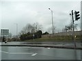
3
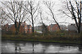
Housing development off Pillow Way
It is always a major step when housing expansion crosses the outer ring road. There is now a lot of it on former greenfield sites south of the A421. This is viewed across the A421 in rain.
Image: © Bill Boaden
Taken: 24 Nov 2018
0.12 miles
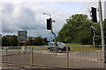
4
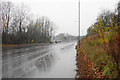
Buckingham bypass
This is the A421 which passes round the south of Buckingham, just approaching the London Road roundabout. It is viewed here in rain.
Image: © Bill Boaden
Taken: 24 Nov 2018
0.15 miles
6
Entrance To Buckingham services off A413
Image: © John Firth
Taken: 23 Dec 2009
0.17 miles
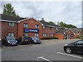
7
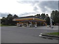
Shell filling station, south of Buckingham
Image: © David Smith
Taken: 24 Aug 2017
0.17 miles
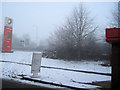
10
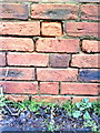
Benchmark on roadside wall of outbuilding at Bourton Mill
Ordnance Survey cut mark benchmark described on the Bench Mark Database at http://www.bench-marks.org.uk/bm36885
Image: © Roger Templeman
Taken: 11 Feb 2011
0.18 miles