IMAGES TAKEN NEAR TO
Lark Close, BUCKINGHAM, MK18 7EZ
Introduction
This page details the photographs taken nearby to Lark Close, MK18 7EZ by members of the Geograph project.
The Geograph project started in 2005 with the aim of publishing, organising and preserving representative images for every square kilometre of Great Britain, Ireland and the Isle of Man.

There are currently over 7.5m images from over14,400 individuals and you can help contribute to the project by visiting https://www.geograph.org.uk
Image Map
Images are licensed for reuse under creativecommons.org/licenses/by-sa/2.0
Notes
- Clicking on the map will re-center to the selected point.
- The higher the marker number, the further away the image location is from the centre of the postcode.
Image Listing (37 Images Found)
Images are licensed for reuse under creativecommons.org/licenses/by-sa/2.0
Image
Details
Distance
1
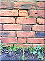
Benchmark on roadside wall of outbuilding at Bourton Mill
Ordnance Survey cut mark benchmark described on the Bench Mark Database at http://www.bench-marks.org.uk/bm36885
Image: © Roger Templeman
Taken: 11 Feb 2011
0.02 miles
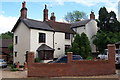
3
Bourton Mill, Buckingham
Now converted to a health club.
Image: © Mark R Dornan
Taken: 12 May 2007
0.04 miles
4
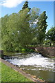
Weir on the river Ouse, Bourton Mill, Buckingham
This new weir was constructed as part of a programme of flood defences.
Image: © Mark R Dornan
Taken: 12 May 2007
0.06 miles
5
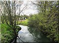
River Great Ouse in Bourton Park, Buckingham
In the far distance is Bourton Mill.
Image: © P L Chadwick
Taken: 24 Apr 2016
0.07 miles
6
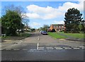
Badgers Way, Buckingham
A long residential road with many roads off. Viewed from Bourton Road. In the distance, on the right, is one of the roads off called Otters Brook.
Image: © P L Chadwick
Taken: 24 Apr 2016
0.08 miles
7
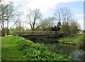
Footbridge over River Great Ouse, Buckingham
The footbridge connects Bourton Park with Bourton Road, which is on the right in this view.
Image: © P L Chadwick
Taken: 24 Apr 2016
0.08 miles
8
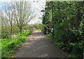
Footpath to Bourton Park from Bourton Road, Buckingham
The footpath commences at Bourton Road (opposite Badgers Way) and crosses the River Great Ouse by the footbridge seen in this view.
Image: © P L Chadwick
Taken: 24 Apr 2016
0.08 miles
9
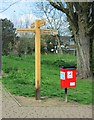
Fingerpost and dog waste bin in Bourton Park, Buckingham
The fingerpost and bin are to be found at an intersection of two footpaths. The park is a popular place for dog walking.
Image
Image: © P L Chadwick
Taken: 24 Apr 2016
0.09 miles
10
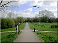
Footpath intersection, Bourton Park, Buckingham
The footpath running left to right is part of the 61 mile Bernwood Jubilee Way. The other path commenced at Bourton Road and is crossing the park until it forms a T-junction with another footpath.
Image: © P L Chadwick
Taken: 24 Apr 2016
0.09 miles