IMAGES TAKEN NEAR TO
Bourton, BUCKINGHAM, MK18 7DU
Introduction
This page details the photographs taken nearby to MK18 7DU by members of the Geograph project.
The Geograph project started in 2005 with the aim of publishing, organising and preserving representative images for every square kilometre of Great Britain, Ireland and the Isle of Man.

There are currently over 7.5m images from over14,400 individuals and you can help contribute to the project by visiting https://www.geograph.org.uk
Image Map
Images are licensed for reuse under creativecommons.org/licenses/by-sa/2.0
Notes
- Clicking on the map will re-center to the selected point.
- The higher the marker number, the further away the image location is from the centre of the postcode.
Image Listing (39 Images Found)
Images are licensed for reuse under creativecommons.org/licenses/by-sa/2.0
Image
Details
Distance
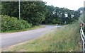
1
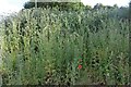
Wild flowers behind the A413, Buckingham
Image: © David Howard
Taken: 13 Jun 2020
0.01 miles
2
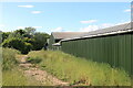
Path by the A413, Buckingham
The barn has been recently rebuilt.
Image: © David Howard
Taken: 13 Jun 2020
0.02 miles
3
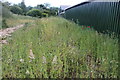
Wild flowers behind the A413, Buckingham
Image: © David Howard
Taken: 13 Jun 2020
0.02 miles
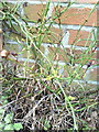
4
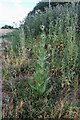
Teasel plant behind the A413, Buckingham
Image: © David Howard
Taken: 13 Jun 2020
0.02 miles
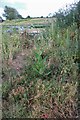
7
Benchmark behind a rose at #1 Home Farm Cottages
Ordnance Survey cut mark benchmark described on the Bench Mark Database at http://www.bench-marks.org.uk/bm36886
Image: © Roger Templeman
Taken: 11 Feb 2011
0.03 miles
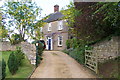
8
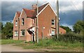
Houses on Bernwood Jubilee Way, Buckingham
Image: © David Howard
Taken: 13 Jun 2020
0.03 miles
10
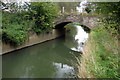
Bridge taking the path over the Ouse
Image: © Philip Jeffrey
Taken: 4 Oct 2012
0.06 miles