IMAGES TAKEN NEAR TO
Bourton, BUCKINGHAM, MK18 7DS
Introduction
This page details the photographs taken nearby to MK18 7DS by members of the Geograph project.
The Geograph project started in 2005 with the aim of publishing, organising and preserving representative images for every square kilometre of Great Britain, Ireland and the Isle of Man.

There are currently over 7.5m images from over14,400 individuals and you can help contribute to the project by visiting https://www.geograph.org.uk
Image Map
Images are licensed for reuse under creativecommons.org/licenses/by-sa/2.0
Notes
- Clicking on the map will re-center to the selected point.
- The higher the marker number, the further away the image location is from the centre of the postcode.
Image Listing (32 Images Found)
Images are licensed for reuse under creativecommons.org/licenses/by-sa/2.0
Image
Details
Distance
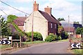
3
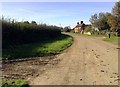
Manor Farm (old A421)
Looking east-n-e along the former A421 towards Manor Farm near Bourton, Buckingham. Although navigable, this part of the road is gated and private.
Image: © mick finn
Taken: 11 Oct 2008
0.04 miles
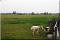
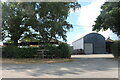
7
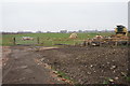
Farmland near Manor Farm
The sheep have an old combine harvester and a potential bonfire on their grazing land.
Image: © Bill Boaden
Taken: 24 Nov 2018
0.08 miles
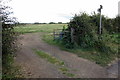
8
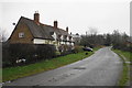
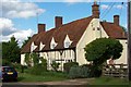
Cottages on Bourton Road
This used to be the A421 into Buckingham before the southern bypass was built.
Image: © Bill Boaden
Taken: 24 Nov 2018
0.08 miles