IMAGES TAKEN NEAR TO
Leckhampstead, BUCKINGHAM, MK18 5NY
Introduction
This page details the photographs taken nearby to MK18 5NY by members of the Geograph project.
The Geograph project started in 2005 with the aim of publishing, organising and preserving representative images for every square kilometre of Great Britain, Ireland and the Isle of Man.

There are currently over 7.5m images from over14,400 individuals and you can help contribute to the project by visiting https://www.geograph.org.uk
Image Map
Images are licensed for reuse under creativecommons.org/licenses/by-sa/2.0
Notes
- Clicking on the map will re-center to the selected point.
- The higher the marker number, the further away the image location is from the centre of the postcode.
Image Listing (5 Images Found)
Images are licensed for reuse under creativecommons.org/licenses/by-sa/2.0
Image
Details
Distance
1
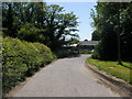
Wicken Road
Wicken Road passing over Limes End Bridge
Image: © Shaun Ferguson
Taken: 16 Jun 2010
0.09 miles
2
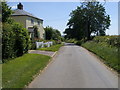
Wicken Road
Wicken Road by Limes End
Image: © Shaun Ferguson
Taken: 16 Jun 2010
0.14 miles
3
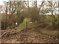
Bridleway Entrance
This bridleway runs into the stream just below South End Bridge Farm. Apparently very fun to ride through my walking companion told me.
Image: © Mr Biz
Taken: 14 Mar 2007
0.17 miles