IMAGES TAKEN NEAR TO
Main Street, BUCKINGHAM, MK18 5LY
Introduction
This page details the photographs taken nearby to Main Street, MK18 5LY by members of the Geograph project.
The Geograph project started in 2005 with the aim of publishing, organising and preserving representative images for every square kilometre of Great Britain, Ireland and the Isle of Man.

There are currently over 7.5m images from over14,400 individuals and you can help contribute to the project by visiting https://www.geograph.org.uk
Image Map
Images are licensed for reuse under creativecommons.org/licenses/by-sa/2.0
Notes
- Clicking on the map will re-center to the selected point.
- The higher the marker number, the further away the image location is from the centre of the postcode.
Image Listing (7 Images Found)
Images are licensed for reuse under creativecommons.org/licenses/by-sa/2.0
Image
Details
Distance
1
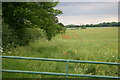
Poppies in the field
Poppies in the field by the footpath North of Shalstone
Image: © Shaun Ferguson
Taken: 17 Jun 2007
0.10 miles
3
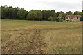
Fields looking down to Shalstone
Looking South across the fields to the village of Shalstone
Image: © Shaun Ferguson
Taken: 17 Jun 2007
0.13 miles
4
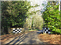
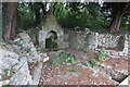
Bridge over a brook, Shalstone
Did Silverstone, which is not far away, inspire the chequered patches?
Image: © Robin Webster
Taken: 4 Dec 2016
0.14 miles
6
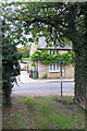
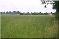
Footpath to Shalstone Grounds Farm
Though the sign points into someone's drive and I could see no way to make progress from there
Image: © Philip Jeffrey
Taken: 16 Sep 2018
0.25 miles
7
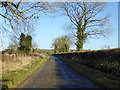
Main Street north of Shalstone
A way to Syresham.
Image: © Robin Webster
Taken: 4 Dec 2016
0.25 miles