IMAGES TAKEN NEAR TO
Main Road, BUCKINGHAM, MK18 5JY
Introduction
This page details the photographs taken nearby to Main Road, MK18 5JY by members of the Geograph project.
The Geograph project started in 2005 with the aim of publishing, organising and preserving representative images for every square kilometre of Great Britain, Ireland and the Isle of Man.

There are currently over 7.5m images from over14,400 individuals and you can help contribute to the project by visiting https://www.geograph.org.uk
Image Map
Images are licensed for reuse under creativecommons.org/licenses/by-sa/2.0
Notes
- Clicking on the map will re-center to the selected point.
- The higher the marker number, the further away the image location is from the centre of the postcode.
Image Listing (27 Images Found)
Images are licensed for reuse under creativecommons.org/licenses/by-sa/2.0
Image
Details
Distance
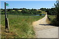
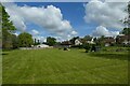
2
Road through Dadford Village
Looking through the village on the Silverstone to Buckingham road.
Image: © DS Pugh
Taken: 28 May 2022
0.05 miles
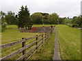
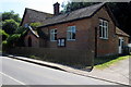
6
Grassy area in Dadford
A footpath leads to the High Street.
Image: © DS Pugh
Taken: 28 May 2022
0.09 miles
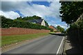
7
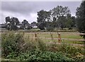
Fields in Dadford
Looking towards the High Street which doesn't go anywhere.
Image: © David Howard
Taken: 17 Sep 2023
0.09 miles

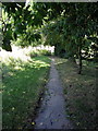
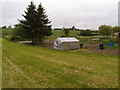
9
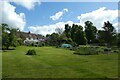
Allotments in Dadford
Viewed from a footpath leading from High Street.
Image: © DS Pugh
Taken: 28 May 2022
0.11 miles