IMAGES TAKEN NEAR TO
Foscott, BUCKINGHAM, MK18 5EX
Introduction
This page details the photographs taken nearby to MK18 5EX by members of the Geograph project.
The Geograph project started in 2005 with the aim of publishing, organising and preserving representative images for every square kilometre of Great Britain, Ireland and the Isle of Man.

There are currently over 7.5m images from over14,400 individuals and you can help contribute to the project by visiting https://www.geograph.org.uk
Image Map
Images are licensed for reuse under creativecommons.org/licenses/by-sa/2.0
Notes
- Clicking on the map will re-center to the selected point.
- The higher the marker number, the further away the image location is from the centre of the postcode.
Image Listing (11 Images Found)
Images are licensed for reuse under creativecommons.org/licenses/by-sa/2.0
Image
Details
Distance
4

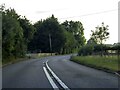
Aylesbury Vale : The A422
The A422 heading from Buckingham to Milton Keynes.
Image: © Lewis Clarke
Taken: 18 Mar 2019
0.18 miles
9
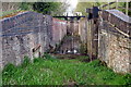
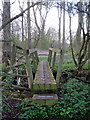
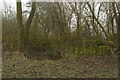
Hyde Lane Lock undergoing restoration
Image: © Philip Jeffrey
Taken: 25 Apr 2013
0.23 miles
10
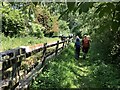
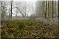
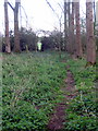
Looking along Buckingham Canal
This short section is all that's left of the canal in this area.
Image: © Lynn Jackson
Taken: 10 Jun 2023
0.23 miles