IMAGES TAKEN NEAR TO
Water Stratford, BUCKINGHAM, MK18 5DR
Introduction
This page details the photographs taken nearby to MK18 5DR by members of the Geograph project.
The Geograph project started in 2005 with the aim of publishing, organising and preserving representative images for every square kilometre of Great Britain, Ireland and the Isle of Man.

There are currently over 7.5m images from over14,400 individuals and you can help contribute to the project by visiting https://www.geograph.org.uk
Image Map
Images are licensed for reuse under creativecommons.org/licenses/by-sa/2.0
Notes
- Clicking on the map will re-center to the selected point.
- The higher the marker number, the further away the image location is from the centre of the postcode.
Image Listing (10 Images Found)
Images are licensed for reuse under creativecommons.org/licenses/by-sa/2.0
Image
Details
Distance
2
House on Water Stratford Road, Water Stratford
Image: © Ian S
Taken: 9 Oct 2020
0.10 miles
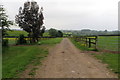
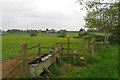
4
Path heading for the A422
From near Manor Farm the path cuts across the field heading for the A422
Image: © Shaun Ferguson
Taken: 7 Jun 2021
0.15 miles
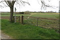
5
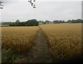
Footpath to Shalstone
A clear route through a rather wet field of wheat.
Image: © Jonathan Thacker
Taken: 2 Aug 2017
0.15 miles
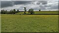
6
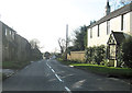
South through Water Stratford
From minor road junction
Image: © John Firth
Taken: 22 Dec 2011
0.16 miles
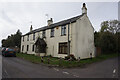
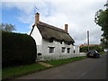
7
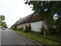
Thatched cottage on Water Stratford Road, Water Stratford
Image: © JThomas
Taken: 28 Sep 2019
0.18 miles
9
Thatched cottage on Water Stratford Road, Water Stratford
Image: © JThomas
Taken: 28 Sep 2019
0.20 miles
10
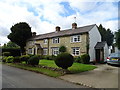
Cottages on Water Stratford Road, Water Stratford
Image: © JThomas
Taken: 28 Sep 2019
0.22 miles