IMAGES TAKEN NEAR TO
Lillingstone Lovell, BUCKINGHAM, MK18 5BS
Introduction
This page details the photographs taken nearby to MK18 5BS by members of the Geograph project.
The Geograph project started in 2005 with the aim of publishing, organising and preserving representative images for every square kilometre of Great Britain, Ireland and the Isle of Man.

There are currently over 7.5m images from over14,400 individuals and you can help contribute to the project by visiting https://www.geograph.org.uk
Image Map
Images are licensed for reuse under creativecommons.org/licenses/by-sa/2.0
Notes
- Clicking on the map will re-center to the selected point.
- The higher the marker number, the further away the image location is from the centre of the postcode.
Image Listing (7 Images Found)
Images are licensed for reuse under creativecommons.org/licenses/by-sa/2.0
Image
Details
Distance

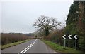
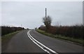
2
Triangle road junction near Lillingstone Lovell
The main A413 road from Buckingham to Towcester runs across the photo, the road from Lillingstone Lovell splits into two approaching it and encloses a grassy triangle.
Image: © Jennifer Vaughan
Taken: 30 Apr 2006
0.05 miles
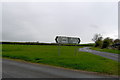
3
Triangular green at road junction
The grassed triangle is the result of road straightening. The course of the A413 used to follow the road on the left and then turn through a right angle to the right. Now the arms of that right angle provide access to the A413 from the old road junction. The straightening also provided a lay-by for a bus stop
Image: © David Smith
Taken: 17 Oct 2012
0.05 miles
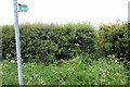
6
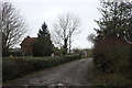
The entrance to Keyes Farm. Lillingstone Lovell
Image: © David Howard
Taken: 28 Dec 2019
0.20 miles