IMAGES TAKEN NEAR TO
Lillingstone Lovell, BUCKINGHAM, MK18 5BE
Introduction
This page details the photographs taken nearby to MK18 5BE by members of the Geograph project.
The Geograph project started in 2005 with the aim of publishing, organising and preserving representative images for every square kilometre of Great Britain, Ireland and the Isle of Man.

There are currently over 7.5m images from over14,400 individuals and you can help contribute to the project by visiting https://www.geograph.org.uk
Image Map
Images are licensed for reuse under creativecommons.org/licenses/by-sa/2.0
Notes
- Clicking on the map will re-center to the selected point.
- The higher the marker number, the further away the image location is from the centre of the postcode.
Image Listing (24 Images Found)
Images are licensed for reuse under creativecommons.org/licenses/by-sa/2.0
Image
Details
Distance
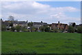
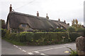
1
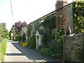
Lillingstone Lovell
Cottages near the Church.
Image: © Ian Rob
Taken: 2 Jun 2007
0.05 miles
3
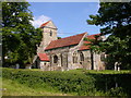
Lillingstone Lovell
The Church of The Assumption of the Blessed Virgin Mary.
Image: © Ian Rob
Taken: 2 Jun 2007
0.14 miles
4
Lillingstone Lovell church
14th century church, tower built in 1210.
Image: © Jennifer Vaughan
Taken: 29 Apr 2006
0.14 miles
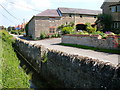
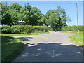
6
Road to the Church
Approaching the Church in Lillingstone Lovell
Image: © Richard Smith
Taken: 3 May 2009
0.14 miles
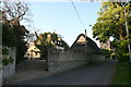
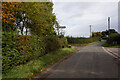
8
Junction with the Wicken to Lillingstone Lovell Road
Road from Akeley at the junction with the Wicken to Lillingstone Lovell Road
Image: © Shaun Ferguson
Taken: 16 Jun 2010
0.15 miles
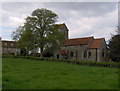
10
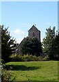
St Mary's church Lillingstone Lovell
Originally a C13 church rebuilt in C14 and restored in C19. The lower part of the tower and the south doorway are C13.
Image: © Bikeboy
Taken: 21 Aug 2014
0.16 miles