IMAGES TAKEN NEAR TO
Lillingstone Dayrell, BUCKINGHAM, MK18 5AU
Introduction
This page details the photographs taken nearby to MK18 5AU by members of the Geograph project.
The Geograph project started in 2005 with the aim of publishing, organising and preserving representative images for every square kilometre of Great Britain, Ireland and the Isle of Man.

There are currently over 7.5m images from over14,400 individuals and you can help contribute to the project by visiting https://www.geograph.org.uk
Image Map
Images are licensed for reuse under creativecommons.org/licenses/by-sa/2.0
Notes
- Clicking on the map will re-center to the selected point.
- The higher the marker number, the further away the image location is from the centre of the postcode.
Image Listing (5 Images Found)
Images are licensed for reuse under creativecommons.org/licenses/by-sa/2.0
Image
Details
Distance
1
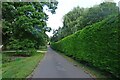
Lillingstone Dayrell Footpath
To Pond Farm and onto Silverstone Racetrack.
Image: © Ian Rob
Taken: 29 Jul 2021
0.08 miles
2
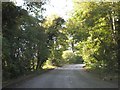
A413 crossing stream near Pond Farm
The road runs through woodland, where two streams run as tributaries to the Great Ouse
Image: © David Smith
Taken: 17 Oct 2012
0.14 miles
3
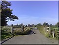
Lane at Dayrell
A lane leading from Manor Farm at Lillingstone Dayrell to the A413.
Image: © mick finn
Taken: 12 Oct 2008
0.15 miles
4
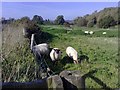
Sheep grazing
An inquisitive sheep seeks glory as its fellow animals get on with their toil in a scruffy but appealing field.
Image: © mick finn
Taken: 12 Oct 2008
0.23 miles
5
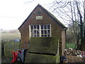
Former Telephone Exchange, Lillingstone Dayrell
Situated down a path off Bycell Road near the A413 road junction, this former telephone exchange seems now to be used as a shed. It was replaced in the early 1970s by the telephone exchange in Chapel Lane, Akeley http://www.geograph.org.uk/photo/1401351
Image: © David Hillas
Taken: 7 Mar 2009
0.24 miles