IMAGES TAKEN NEAR TO
Akeley, BUCKINGHAM, MK18 5AE
Introduction
This page details the photographs taken nearby to MK18 5AE by members of the Geograph project.
The Geograph project started in 2005 with the aim of publishing, organising and preserving representative images for every square kilometre of Great Britain, Ireland and the Isle of Man.

There are currently over 7.5m images from over14,400 individuals and you can help contribute to the project by visiting https://www.geograph.org.uk
Image Map
Images are licensed for reuse under creativecommons.org/licenses/by-sa/2.0
Notes
- Clicking on the map will re-center to the selected point.
- The higher the marker number, the further away the image location is from the centre of the postcode.
Image Listing (7 Images Found)
Images are licensed for reuse under creativecommons.org/licenses/by-sa/2.0
Image
Details
Distance

3
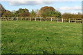
Stowe Castle Bycell Road
Built before 1738 a Grade II listed farmhouse built by Lord Cobham probably designed by James Gibbs (1682-1754) who did various garden temples at Stowe Park between 1726 and 1749.
Image: © Jo and Steve Turner
Taken: 5 Jul 2012
0.18 miles
4
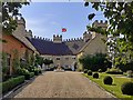
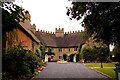
Stowe Castle
On the eastern edge of Stowe Park.
Image: © Ian Rob
Taken: 24 Aug 2019
0.18 miles
6

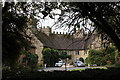
Stowe Castle
The building is an eyecatcher (folly) hiding some cottages in its interior
Image: © David Smith
Taken: 17 Oct 2012
0.20 miles