IMAGES TAKEN NEAR TO
Maids Moreton, BUCKINGHAM, MK18 5AA
Introduction
This page details the photographs taken nearby to MK18 5AA by members of the Geograph project.
The Geograph project started in 2005 with the aim of publishing, organising and preserving representative images for every square kilometre of Great Britain, Ireland and the Isle of Man.

There are currently over 7.5m images from over14,400 individuals and you can help contribute to the project by visiting https://www.geograph.org.uk
Image Map
Images are licensed for reuse under creativecommons.org/licenses/by-sa/2.0
Notes
- Clicking on the map will re-center to the selected point.
- The higher the marker number, the further away the image location is from the centre of the postcode.
Image Listing (7 Images Found)
Images are licensed for reuse under creativecommons.org/licenses/by-sa/2.0
Image
Details
Distance
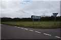
1
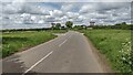
Bycell Road at the Crossroads
Bycell Road at the crossroads with the Clackmore to Akeley Road
Image: © Shaun Ferguson
Taken: 7 Jun 2021
0.05 miles
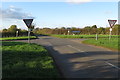
3
Countryside Crossroads
A busy crossroads around the F1 weekend, with people taking these back-roads heading towards Chackmore.
Image: © Mr Biz
Taken: 6 Apr 2007
0.07 miles
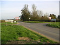
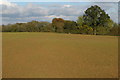
4
Crossroads near Bycell Farm
The two roads that cross here run straight for some distance either side. As a road safety measure, the fields in the corners have been cut back to give a large diamond open space, allowing a view of approaching traffic.
Image: © David Smith
Taken: 17 Oct 2012
0.08 miles
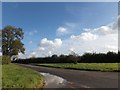
7
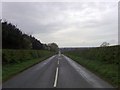
From Akeley to Chackmore
The road from Akeley near the crossroads with Bycell Road. Looking towards Chackmore.
Image: © mick finn
Taken: 11 Apr 2009
0.18 miles