IMAGES TAKEN NEAR TO
Langland Close, BUCKINGHAM, MK18 4NE
Introduction
This page details the photographs taken nearby to Langland Close, MK18 4NE by members of the Geograph project.
The Geograph project started in 2005 with the aim of publishing, organising and preserving representative images for every square kilometre of Great Britain, Ireland and the Isle of Man.

There are currently over 7.5m images from over14,400 individuals and you can help contribute to the project by visiting https://www.geograph.org.uk
Image Map (Loading...)


Getting Data...Please wait
Leaflet Map data © OpenStreetMap
Images are licensed for reuse under creativecommons.org/licenses/by-sa/2.0
Notes
- Clicking on the map will re-center to the selected point.
- The higher the marker number, the further away the image location is from the centre of the postcode.
Image Listing (19 Images Found)
Images are licensed for reuse under creativecommons.org/licenses/by-sa/2.0
Image
Details
Distance

2
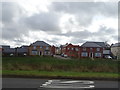
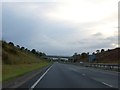
Aylesbury Vale : The A421
The A421 heading through the Aylesbury Vale District.
Image: © Lewis Clarke
Taken: 18 Mar 2019
0.04 miles
5
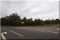
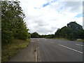
Road to Tingewick
Descending from crossing over the A421 Tingewick bypass. The village is to the left at the junction.
Image: © Robin Webster
Taken: 20 Oct 2018
0.07 miles
6
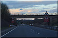
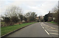
Bridge over A421 south-east of Tingewick
The bridge carries a minor road to Gawcott
Image: © David Smith
Taken: 17 Oct 2012
0.07 miles
9

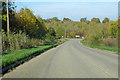
Tingewick Bypass
Looking west, with little traffic.
Image: © Martin Loader
Taken: 8 Apr 2007
0.11 miles
