IMAGES TAKEN NEAR TO
Main Street, BUCKINGHAM, MK18 4LU
Introduction
This page details the photographs taken nearby to Main Street, MK18 4LU by members of the Geograph project.
The Geograph project started in 2005 with the aim of publishing, organising and preserving representative images for every square kilometre of Great Britain, Ireland and the Isle of Man.

There are currently over 7.5m images from over14,400 individuals and you can help contribute to the project by visiting https://www.geograph.org.uk
Image Map
Images are licensed for reuse under creativecommons.org/licenses/by-sa/2.0
Notes
- Clicking on the map will re-center to the selected point.
- The higher the marker number, the further away the image location is from the centre of the postcode.
Image Listing (33 Images Found)
Images are licensed for reuse under creativecommons.org/licenses/by-sa/2.0
Image
Details
Distance
2
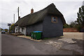
The White Hart public house
On Pound Lane, Preston Bissett.
Image: © Ian S
Taken: 9 Oct 2020
0.04 miles
3
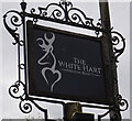
The White Hart public house
On Pound Lane, Preston Bissett.
Image: © Ian S
Taken: 9 Oct 2020
0.05 miles
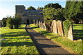
4
St John the Baptist, Preston Bissett
The first recorded rector was Ralph de Neston (13thC).
Image: © mick finn
Taken: 15 Nov 2008
0.05 miles
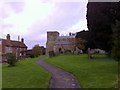
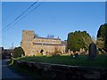
6
St John the Baptist and its churchyard
Image: © Philip Jeffrey
Taken: 17 Jul 2016
0.06 miles
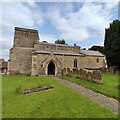
7

St John the Baptist church in Preston Bissett
Image: © Steve Daniels
Taken: 2 Mar 2015
0.06 miles
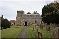
9
St John the Baptist, Preston Bissett
A C14 church incorporating c12 masonry presumably from an earlier structure. Restored C19.
Image: © Bikeboy
Taken: 2 Jan 2015
0.06 miles