IMAGES TAKEN NEAR TO
Chetwode, BUCKINGHAM, MK18 4JZ
Introduction
This page details the photographs taken nearby to MK18 4JZ by members of the Geograph project.
The Geograph project started in 2005 with the aim of publishing, organising and preserving representative images for every square kilometre of Great Britain, Ireland and the Isle of Man.

There are currently over 7.5m images from over14,400 individuals and you can help contribute to the project by visiting https://www.geograph.org.uk
Image Map
Images are licensed for reuse under creativecommons.org/licenses/by-sa/2.0
Notes
- Clicking on the map will re-center to the selected point.
- The higher the marker number, the further away the image location is from the centre of the postcode.
Image Listing (10 Images Found)
Images are licensed for reuse under creativecommons.org/licenses/by-sa/2.0
Image
Details
Distance
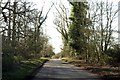
1
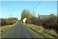
The road to Tingewick
The road runs from Stratton Audley to Tingewick.
Image: © Steve Daniels
Taken: 6 Mar 2015
0.04 miles

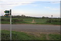
3
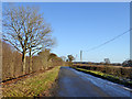
Lane towards Tingewick
This route or its trace parallels the Roman Bicester - Towcester road (partly now the A4421) at a remove of about 1 km for around 10 km, from Stratton Audley to the River Ouse north of Tingewick.
Image: © Robin Webster
Taken: 4 Dec 2016
0.16 miles
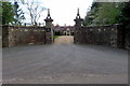
4
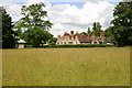
Barton Hartshorn Manor House
From the Bernwood Way looking across to Barton Hartshorn Manor House
Image: © Shaun Ferguson
Taken: 7 Jul 2007
0.17 miles