IMAGES TAKEN NEAR TO
Church Street, BUCKINGHAM, MK18 4EX
Introduction
This page details the photographs taken nearby to Church Street, MK18 4EX by members of the Geograph project.
The Geograph project started in 2005 with the aim of publishing, organising and preserving representative images for every square kilometre of Great Britain, Ireland and the Isle of Man.

There are currently over 7.5m images from over14,400 individuals and you can help contribute to the project by visiting https://www.geograph.org.uk
Image Map
Images are licensed for reuse under creativecommons.org/licenses/by-sa/2.0
Notes
- Clicking on the map will re-center to the selected point.
- The higher the marker number, the further away the image location is from the centre of the postcode.
Image Listing (20 Images Found)
Images are licensed for reuse under creativecommons.org/licenses/by-sa/2.0
Image
Details
Distance
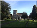
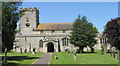
6
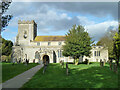
Twyford church
St. Mary's is a grade I listed building, 12th century onwards.
Image: © Robin Webster
Taken: 22 Feb 2014
0.05 miles
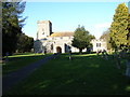
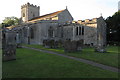
7
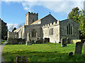
Twyford church
Assumption of the Blessed Virgin Mary - despite the fancy name, a standard Church of England parish church.
Image: © Robin Webster
Taken: 22 Feb 2014
0.05 miles