IMAGES TAKEN NEAR TO
Main Street, BUCKINGHAM, MK18 4EP
Introduction
This page details the photographs taken nearby to Main Street, MK18 4EP by members of the Geograph project.
The Geograph project started in 2005 with the aim of publishing, organising and preserving representative images for every square kilometre of Great Britain, Ireland and the Isle of Man.

There are currently over 7.5m images from over14,400 individuals and you can help contribute to the project by visiting https://www.geograph.org.uk
Image Map
Images are licensed for reuse under creativecommons.org/licenses/by-sa/2.0
Notes
- Clicking on the map will re-center to the selected point.
- The higher the marker number, the further away the image location is from the centre of the postcode.
Image Listing (18 Images Found)
Images are licensed for reuse under creativecommons.org/licenses/by-sa/2.0
Image
Details
Distance
1

The bus shelter in Twyford
A mural has been painted on the inside of the shelter.
Image: © Steve Daniels
Taken: 1 Jul 2014
0.05 miles
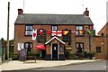
3
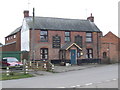
The Crown, Twyford (Bucks)
Basic village boozer with two real beers.
Image: © al partington
Taken: 3 Jan 2008
0.09 miles
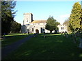

10

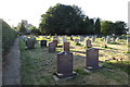
Graveyard, Twyford
A quite large extension of the churchyard.
Image: © Robin Webster
Taken: 22 Feb 2014
0.18 miles