IMAGES TAKEN NEAR TO
Twyford, BUCKINGHAM, MK18 4EA
Introduction
This page details the photographs taken nearby to MK18 4EA by members of the Geograph project.
The Geograph project started in 2005 with the aim of publishing, organising and preserving representative images for every square kilometre of Great Britain, Ireland and the Isle of Man.

There are currently over 7.5m images from over14,400 individuals and you can help contribute to the project by visiting https://www.geograph.org.uk
Image Map
Images are licensed for reuse under creativecommons.org/licenses/by-sa/2.0
Notes
- Clicking on the map will re-center to the selected point.
- The higher the marker number, the further away the image location is from the centre of the postcode.
Image Listing (11 Images Found)
Images are licensed for reuse under creativecommons.org/licenses/by-sa/2.0
Image
Details
Distance
1
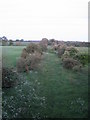
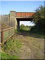
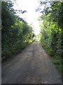
Dismantled railway near Portway Farm
Looking south-east from a road bridge on the unclassified road between Twyford and Three Bridge Mill, this is the trackbed of the former Great Central Railway. This line when it opened in 1899 was the last main line double track railway to be built, and it ran between Sheffield, Nottingham and London Marylebone, see Image The nearest stations were Calvert, 2km to the south-east, and Finmere in Northamptonshire, 8km to the north-west. The railway was dismantled in 1966.
Image: © Andy Gryce
Taken: 19 May 2007
0.02 miles
2
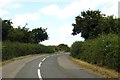
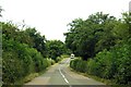
The road to Steeple Claydon
The road runs over a disused railway which is now the proposed route for HS2.
Image: © Steve Daniels
Taken: 1 Jul 2014
0.04 miles
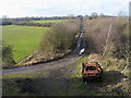
3
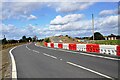
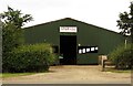
Diverted road
The road has been diverted around the old railway bridge (GCR No. 558), centre of picture. The new HS2 railway line will pass just beyond the bridge in a cutting.
Image: © Bob Walters
Taken: 1 Oct 2022
0.04 miles
4
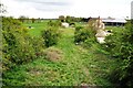
Portway Farm from GCR Bridge 558
A view south east from GCR Bridge No.558 showing the former Great Central Railway trackbed passing Portway Farm on the right. The line was closed in 1966, but now the new HS2 railway is being built here, and will pass just to the left of this scene.
Image: © Bob Walters
Taken: 25 Apr 2019
0.05 miles
5
Dismantled railway near Portway Farm 2
Looking south-east, this is a plate girder road bridge over the trackbed of the former Great Central Railway, which when it opened in 1899 was the last main line double track railway to be built, see also Image
Image: © Andy Gryce
Taken: 30 Aug 2008
0.05 miles
9
Dismantled railway near Portway Farm 3
Looking north-west, this is the trackbed of the former Great Central Railway, which when it opened in 1899 was the last main line double track railway to be built, see also Image Here the trackbed is now an access road to some buildings 400m away. Behind the camera is a road bridge over the railway, Image
Image: © Andy Gryce
Taken: 30 Aug 2008
0.16 miles
10
Dismantled Railway
Dismantled Railway heading up past in the distance Twyford Church tower
Image: © Shaun Ferguson
Taken: 19 Feb 2010
0.17 miles