IMAGES TAKEN NEAR TO
Preston Bissett, BUCKINGHAM, MK18 4DP
Introduction
This page details the photographs taken nearby to MK18 4DP by members of the Geograph project.
The Geograph project started in 2005 with the aim of publishing, organising and preserving representative images for every square kilometre of Great Britain, Ireland and the Isle of Man.

There are currently over 7.5m images from over14,400 individuals and you can help contribute to the project by visiting https://www.geograph.org.uk
Image Map
Images are licensed for reuse under creativecommons.org/licenses/by-sa/2.0
Notes
- Clicking on the map will re-center to the selected point.
- The higher the marker number, the further away the image location is from the centre of the postcode.
Image Listing (12 Images Found)
Images are licensed for reuse under creativecommons.org/licenses/by-sa/2.0
Image
Details
Distance

4
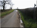
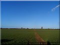
Road nearing Casemore Farm
Passing footpath road nearing Casemore Farm
Image: © Shaun Ferguson
Taken: 10 Apr 2010
0.08 miles


7
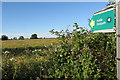
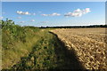
Footpath towards Preston Bissett
Somewhat overgrown so I doubt it gets much use as it only cuts a few yards off using the road
Image: © Philip Jeffrey
Taken: 17 Jul 2016
0.15 miles