IMAGES TAKEN NEAR TO
Hillesden, BUCKINGHAM, MK18 4BZ
Introduction
This page details the photographs taken nearby to MK18 4BZ by members of the Geograph project.
The Geograph project started in 2005 with the aim of publishing, organising and preserving representative images for every square kilometre of Great Britain, Ireland and the Isle of Man.

There are currently over 7.5m images from over14,400 individuals and you can help contribute to the project by visiting https://www.geograph.org.uk
Image Map
Images are licensed for reuse under creativecommons.org/licenses/by-sa/2.0
Notes
- Clicking on the map will re-center to the selected point.
- The higher the marker number, the further away the image location is from the centre of the postcode.
Image Listing (33 Images Found)
Images are licensed for reuse under creativecommons.org/licenses/by-sa/2.0
Image
Details
Distance
1
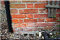
Benchmark on #3 The Orchard
Ordnance Survey cut mark benchmark described on the Bench Mark Database at http://www.bench-marks.org.uk/bm82499
Image: © Roger Templeman
Taken: 2 Mar 2017
0.00 miles
2
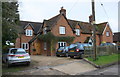
#1-3 The Orchard
There is an OS benchmark Image on the near corner of the forward jut of the left hand house, left of its trellis
Image: © Roger Templeman
Taken: 2 Mar 2017
0.01 miles
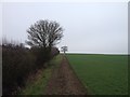
5
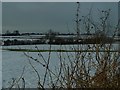
Snowy Field
Looking across summer pasture field towards Lower Hillesden, Jubilee Farm.
Image: © Sally Dignam-Thomas
Taken: 12 Feb 2009
0.09 miles
6
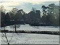
Let it snow
All Saints' Church Hillesden taken from photographer's garden.
Image: © Sally Dignam-Thomas
Taken: 12 Feb 2009
0.14 miles

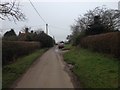
10
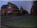
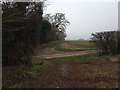
Evening Gloom, Hillesden
Looking through a gateway leading to Hillesden House. The Cross Bucks Way takes this route.
Image: © Colin Smith
Taken: 2 Jan 2010
0.21 miles