IMAGES TAKEN NEAR TO
Lenborough, BUCKINGHAM, MK18 4BS
Introduction
This page details the photographs taken nearby to MK18 4BS by members of the Geograph project.
The Geograph project started in 2005 with the aim of publishing, organising and preserving representative images for every square kilometre of Great Britain, Ireland and the Isle of Man.

There are currently over 7.5m images from over14,400 individuals and you can help contribute to the project by visiting https://www.geograph.org.uk
Image Map
Images are licensed for reuse under creativecommons.org/licenses/by-sa/2.0
Notes
- Clicking on the map will re-center to the selected point.
- The higher the marker number, the further away the image location is from the centre of the postcode.
Image Listing (5 Images Found)
Images are licensed for reuse under creativecommons.org/licenses/by-sa/2.0
Image
Details
Distance
3
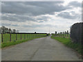
Road to Manor Farm
A public bridleway.
Image: © Robin Webster
Taken: 27 Mar 2015
0.14 miles
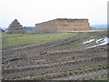
5

Drive to Quest depot
Quest supply mainly architectural fittings and associated tools, particularly door furniture. It seems to be trade only.
The substantial drive, well fenced site and the main building are interesting, together with the adjacent Little Oaks Farm. They were built for a radio station that was set up here around WWII, with mast arrays in the nearby fields. Latterly, at least, it was part of the Diplomatic Wireless Service, for code communications with British embassies and other less obvious British agencies abroad.
Image: © Robin Webster
Taken: 27 Mar 2015
0.18 miles