IMAGES TAKEN NEAR TO
Radclive Road, BUCKINGHAM, MK18 4AA
Introduction
This page details the photographs taken nearby to Radclive Road, MK18 4AA by members of the Geograph project.
The Geograph project started in 2005 with the aim of publishing, organising and preserving representative images for every square kilometre of Great Britain, Ireland and the Isle of Man.

There are currently over 7.5m images from over14,400 individuals and you can help contribute to the project by visiting https://www.geograph.org.uk
Image Map
Images are licensed for reuse under creativecommons.org/licenses/by-sa/2.0
Notes
- Clicking on the map will re-center to the selected point.
- The higher the marker number, the further away the image location is from the centre of the postcode.
Image Listing (6 Images Found)
Images are licensed for reuse under creativecommons.org/licenses/by-sa/2.0
Image
Details
Distance
3
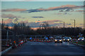
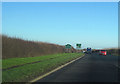
Aylesbury Vale : The A421
The A421 heading through the Aylesbury Vale District.
Image: © Lewis Clarke
Taken: 18 Mar 2019
0.22 miles
4
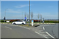
A421 roundabout west of Buckingham
The A421 is left and right. Looking from Redclive Road, which continues straight on to Redclive.
Image: © Robin Webster
Taken: 22 Mar 2020
0.23 miles
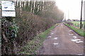
5
Entering Buckingham
Just west of the Tingewick Road industrial estate turn off from A421
Image: © John Firth
Taken: 22 Dec 2011
0.24 miles
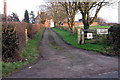
6

Hartridge Ltd.
These newly built offices on Radclive Road between Gawcott and Radclive belong to Hardtridge Limited, who claim to be the "world leaders in Diesel Fuel Systems Test & Service Equipment". The building is right up against the eastern gridline of this square.
Their website http://www.hartridge.com/
Image: © Rob Farrow
Taken: 23 Feb 2007
0.25 miles