IMAGES TAKEN NEAR TO
Granborough Road, BUCKINGHAM, MK18 3RZ
Introduction
This page details the photographs taken nearby to Granborough Road, MK18 3RZ by members of the Geograph project.
The Geograph project started in 2005 with the aim of publishing, organising and preserving representative images for every square kilometre of Great Britain, Ireland and the Isle of Man.

There are currently over 7.5m images from over14,400 individuals and you can help contribute to the project by visiting https://www.geograph.org.uk
Image Map
Images are licensed for reuse under creativecommons.org/licenses/by-sa/2.0
Notes
- Clicking on the map will re-center to the selected point.
- The higher the marker number, the further away the image location is from the centre of the postcode.
Image Listing (3 Images Found)
Images are licensed for reuse under creativecommons.org/licenses/by-sa/2.0
Image
Details
Distance
1
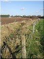
Stream and new unit
This is the view upstream to complement Image The green unit at top left is newly built by the looks of it, and appeared to be being fitted out as I drove past it.
Image: © Rob Farrow
Taken: 6 Nov 2007
0.10 miles
2
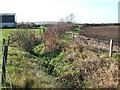
Stream south of Granborough looking downstream
This little stream - one of several in the area - makes a natural field boundary here. This is the view downstream in a southwesterly direction, see also Image]
Image: © Rob Farrow
Taken: 6 Nov 2007
0.12 miles
3
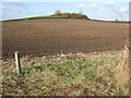
Wooded tump near Wings Farm
This little wooded mound or tump lies approximately halfway between Granborough and North Marston, just south of Wings Farm. The photo was taken from by the little stream whose course can be seen in Image] & Image]
Image: © Rob Farrow
Taken: 6 Nov 2007
0.14 miles