IMAGES TAKEN NEAR TO
St. Johns Lane, BUCKINGHAM, MK18 3PU
Introduction
This page details the photographs taken nearby to St. Johns Lane, MK18 3PU by members of the Geograph project.
The Geograph project started in 2005 with the aim of publishing, organising and preserving representative images for every square kilometre of Great Britain, Ireland and the Isle of Man.

There are currently over 7.5m images from over14,400 individuals and you can help contribute to the project by visiting https://www.geograph.org.uk
Image Map
Images are licensed for reuse under creativecommons.org/licenses/by-sa/2.0
Notes
- Clicking on the map will re-center to the selected point.
- The higher the marker number, the further away the image location is from the centre of the postcode.
Image Listing (3 Images Found)
Images are licensed for reuse under creativecommons.org/licenses/by-sa/2.0
Image
Details
Distance
2
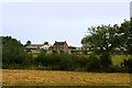
Farmhouse & farm buildings, North Marston
I think this must be Manor Farm in St John's Lane but am open to correction. Taken from the Matthew's Way footpath.
Image: © David Kemp
Taken: 16 Sep 2023
0.15 miles
3
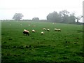
Sheep near Carter's Lane Farm
This photograph was taken opposite Image] looking across the fields in a southwesterly direction. One little black sheep has come to the fore !
Image: © Rob Farrow
Taken: 13 Oct 2006
0.21 miles