IMAGES TAKEN NEAR TO
Quainton Road, BUCKINGHAM, MK18 3PS
Introduction
This page details the photographs taken nearby to Quainton Road, MK18 3PS by members of the Geograph project.
The Geograph project started in 2005 with the aim of publishing, organising and preserving representative images for every square kilometre of Great Britain, Ireland and the Isle of Man.

There are currently over 7.5m images from over14,400 individuals and you can help contribute to the project by visiting https://www.geograph.org.uk
Image Map
Images are licensed for reuse under creativecommons.org/licenses/by-sa/2.0
Notes
- Clicking on the map will re-center to the selected point.
- The higher the marker number, the further away the image location is from the centre of the postcode.
Image Listing (6 Images Found)
Images are licensed for reuse under creativecommons.org/licenses/by-sa/2.0
Image
Details
Distance
1
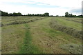
Potters Farmhouse
This farmhouse which can just be glimpsed through the trees is on the western fringe of North Marston near to the junction with a dead-end lane which leads to several farms.
Image: © Rob Farrow
Taken: 13 Oct 2006
0.03 miles
2
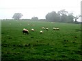
Sheep near Carter's Lane Farm
This photograph was taken opposite Image] looking across the fields in a southwesterly direction. One little black sheep has come to the fore !
Image: © Rob Farrow
Taken: 13 Oct 2006
0.09 miles
4
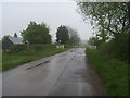
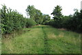
Swan's Way
Swan's Way entering North Marston
Image: © Shaun Ferguson
Taken: 25 Apr 2014
0.15 miles
5
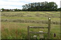
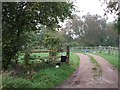
Stile on the footpath into North Marston
Image: © Philip Jeffrey
Taken: 18 Jul 2020
0.19 miles