IMAGES TAKEN NEAR TO
Portway, BUCKINGHAM, MK18 3PL
Introduction
This page details the photographs taken nearby to Portway, MK18 3PL by members of the Geograph project.
The Geograph project started in 2005 with the aim of publishing, organising and preserving representative images for every square kilometre of Great Britain, Ireland and the Isle of Man.

There are currently over 7.5m images from over14,400 individuals and you can help contribute to the project by visiting https://www.geograph.org.uk
Image Map
Images are licensed for reuse under creativecommons.org/licenses/by-sa/2.0
Notes
- Clicking on the map will re-center to the selected point.
- The higher the marker number, the further away the image location is from the centre of the postcode.
Image Listing (97 Images Found)
Images are licensed for reuse under creativecommons.org/licenses/by-sa/2.0
Image
Details
Distance

2
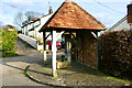
Holy Well, Scorne Lane, North Marston
This edifice marks the site of a well that was supplied by a spring whose waters were claimed to have curative properties. The spring was discovered in 1290 by the then rector of North Marston, Sir John Scorne and until the Reformation the site was a place of pilgrimage. Following a drowning in 1861, the well fell into disuse and was covered over, and by 1900 had been replaced with a pump. The renovations carried out in 2004-5 included the construction of the present shelter.
Image: © David Kemp
Taken: 11 Feb 2022
0.06 miles
4
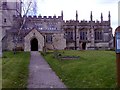
South entrance, North Marston parish church
The south entrance of the Assumption of the Blessed Virgin Mary parish church at North Marston, Bucks. It dates from the 12thC.
Image: © mick finn
Taken: 22 Mar 2009
0.07 miles
5
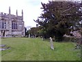
Churchyard at North Marston, Bucks
South side of the churchyard at North Marston. Church Street is beyond the hedge to the right.
Image: © mick finn
Taken: 22 Mar 2009
0.07 miles
6
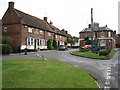
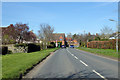
Cottages at North Marston
Modern looking cottages on Church Street, North Marston, Bucks. The parish church is to the left of the hedgerow.
Image: © mick finn
Taken: 22 Mar 2009
0.07 miles
7
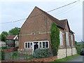
Former Methodist Church, North Marston
Dating from 1864, this chapel is situated in Schorne Lane. It closed for worship at the end of 2004 and seems to been converted into a private dwelling.
Image: © David Hillas
Taken: 25 May 2009
0.08 miles
8
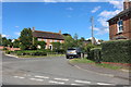
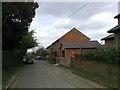
Portway, North Marston
Looking north.
Image: © Robin Webster
Taken: 22 Mar 2020
0.09 miles
9
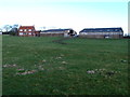
Burnaby Farm
Viewed from the Mathews Way http://northmarston.org/events-matthews-way-walk
Image: © Michael Trolove
Taken: 30 Dec 2012
0.11 miles