IMAGES TAKEN NEAR TO
Shepperds Close, BUCKINGHAM, MK18 3PB
Introduction
This page details the photographs taken nearby to Shepperds Close, MK18 3PB by members of the Geograph project.
The Geograph project started in 2005 with the aim of publishing, organising and preserving representative images for every square kilometre of Great Britain, Ireland and the Isle of Man.

There are currently over 7.5m images from over14,400 individuals and you can help contribute to the project by visiting https://www.geograph.org.uk
Image Map
Images are licensed for reuse under creativecommons.org/licenses/by-sa/2.0
Notes
- Clicking on the map will re-center to the selected point.
- The higher the marker number, the further away the image location is from the centre of the postcode.
Image Listing (6 Images Found)
Images are licensed for reuse under creativecommons.org/licenses/by-sa/2.0
Image
Details
Distance
2
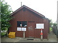
North Marston Telephone Exchange
Situated in Granborough Road, this TE also serves Granborough as well as North Marston. Its postcode is MK18 3PN.
Image: © David Hillas
Taken: 25 May 2009
0.16 miles
3
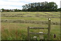
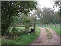
Stile on the footpath into North Marston
Image: © Philip Jeffrey
Taken: 18 Jul 2020
0.19 miles
4
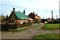
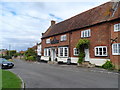
Cottages at north end of High Street, North Marston
Image: © David Kemp
Taken: 11 Feb 2022
0.21 miles
5
Potters Farmhouse
This farmhouse which can just be glimpsed through the trees is on the western fringe of North Marston near to the junction with a dead-end lane which leads to several farms.
Image: © Rob Farrow
Taken: 13 Oct 2006
0.23 miles
6
Pub, North Marston
Now called "The Pilgrim", its traditional name was "The Bell". The building dates from the late C18.
Image: © Bikeboy
Taken: 21 Aug 2014
0.25 miles