IMAGES TAKEN NEAR TO
The Spinney, BUCKINGHAM, MK18 3NR
Introduction
This page details the photographs taken nearby to The Spinney, MK18 3NR by members of the Geograph project.
The Geograph project started in 2005 with the aim of publishing, organising and preserving representative images for every square kilometre of Great Britain, Ireland and the Isle of Man.

There are currently over 7.5m images from over14,400 individuals and you can help contribute to the project by visiting https://www.geograph.org.uk
Image Map
Images are licensed for reuse under creativecommons.org/licenses/by-sa/2.0
Notes
- Clicking on the map will re-center to the selected point.
- The higher the marker number, the further away the image location is from the centre of the postcode.
Image Listing (8 Images Found)
Images are licensed for reuse under creativecommons.org/licenses/by-sa/2.0
Image
Details
Distance

2

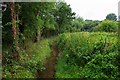
Lesser celandine in Magpie Spinney
Magpie Spinney is a small wet woodland in Winslow.
Image: © Steve Daniels
Taken: 21 Apr 2015
0.07 miles
3
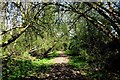
A path through Magpie Spinney
Magpie Spinney is a small wet woodland in Winslow.
Image: © Steve Daniels
Taken: 21 Apr 2015
0.07 miles
5
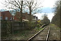
Winslow Rail Station (disused)
The disused railway station in Winslow on the Oxford to Cambridge Varsity Line; westbound platform visible. The last regular passenger trains ran until the end of 1967. The station building was demolished in 1993. East West Rail will reopen and dual track the line between Oxford and Bletchley by December 2017. The recent housing development precludes the rebuilding of the station in its original position. Instead a new station will be built to the north west of the line near to the junction between Buckingham Road and Great Horwood Road. More details http://www.disused-stations.org.uk/w/winslow/ and http://www.winslow-history.org.uk/winslow_railway.shtm and http://www.eastwestrail.org.uk
Image: © Andrew Bodman
Taken: 24 Mar 2014
0.18 miles
6
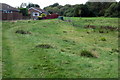
Site of Winslow Rail Station
The original Winslow rail station was once a busy station on the Oxford - Cambridge Varsity line. The last passenger trains ran until the end of 1967. The station building was demolished in 1993; the two cars parked near the centre of the photo identify the position of the original station. East West Rail will reopen and dual track the line between Oxford and Bletchley by December 2017. The recent housing development precludes the rebuilding of the station in its original position. Instead a new station will be built to the north west of the line near to the junction between Buckingham Road and Great Horwood Road. More details http://www.disused-stations.org.uk/w/winslow/ and http://www.winslow-history.org.uk/winslow_railway.shtm and http://www.eastwestrail.org.uk
Image: © Andrew Bodman
Taken: 24 Mar 2014
0.18 miles
8
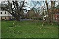
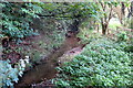
Stream just north of Winslow, Bucks
This is one of a number of small streams which encircle the town of Winslow. All of them eventually discharge into the River Ouse. Photographed from the Little Horwood to Winslow road, just north of Winslow.
The view in the opposite direction:- Image
Image: © P L Chadwick
Taken: 20 Jul 2014
0.24 miles