IMAGES TAKEN NEAR TO
Granborough Road, BUCKINGHAM, MK18 3NG
Introduction
This page details the photographs taken nearby to Granborough Road, MK18 3NG by members of the Geograph project.
The Geograph project started in 2005 with the aim of publishing, organising and preserving representative images for every square kilometre of Great Britain, Ireland and the Isle of Man.

There are currently over 7.5m images from over14,400 individuals and you can help contribute to the project by visiting https://www.geograph.org.uk
Image Map
Images are licensed for reuse under creativecommons.org/licenses/by-sa/2.0
Notes
- Clicking on the map will re-center to the selected point.
- The higher the marker number, the further away the image location is from the centre of the postcode.
Image Listing (12 Images Found)
Images are licensed for reuse under creativecommons.org/licenses/by-sa/2.0
Image
Details
Distance
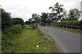
1
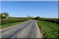
Granborough Road
Granborough Road passing Brook Farm
Image: © Shaun Ferguson
Taken: 16 Jun 2010
0.02 miles
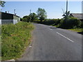
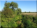
3
Granborough Road towards Winslow
From the bridge over the Claydon Brook.
Image: © JThomas
Taken: 21 Sep 2019
0.07 miles
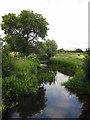
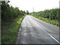
5
The Claydon Brook
View from the bridge on Granborough Road.
Image: © JThomas
Taken: 21 Sep 2019
0.10 miles
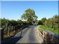
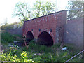
6
Bridge on the Granborough Road
With a vintage Bentley on it
Image: © Philip Jeffrey
Taken: 4 Jul 2013
0.10 miles
8
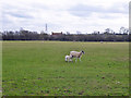
Sheep and lambs
A field by East Claydon Road. It looks like one lamb, but a leg count shows there is another one behind.
Image: © Robin Webster
Taken: 27 Mar 2015
0.19 miles
9
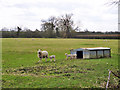
Sheep and lambs
A field by East Claydon Road.
Image: © Robin Webster
Taken: 27 Mar 2015
0.20 miles