IMAGES TAKEN NEAR TO
East Claydon Road, BUCKINGHAM, MK18 3NF
Introduction
This page details the photographs taken nearby to East Claydon Road, MK18 3NF by members of the Geograph project.
The Geograph project started in 2005 with the aim of publishing, organising and preserving representative images for every square kilometre of Great Britain, Ireland and the Isle of Man.

There are currently over 7.5m images from over14,400 individuals and you can help contribute to the project by visiting https://www.geograph.org.uk
Image Map
Images are licensed for reuse under creativecommons.org/licenses/by-sa/2.0
Notes
- Clicking on the map will re-center to the selected point.
- The higher the marker number, the further away the image location is from the centre of the postcode.
Image Listing (24 Images Found)
Images are licensed for reuse under creativecommons.org/licenses/by-sa/2.0
Image
Details
Distance
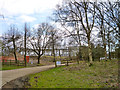
2
Winslow Road railway station (site), Buckinghamshire
Opened in 1868 by the Aylesbury & Buckingham Railway, later part of the Metropolitan Railway, this station closed to passengers in 1936 and completely in 1947.
View south from the former level crossing towards Granborough Road and Quainton Road. The trackbed ran where the left hand of the two wooden huts is sited.
Image: © Nigel Thompson
Taken: 7 Jun 2014
0.02 miles
4
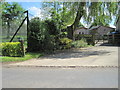
Station Kennels
As well as being dog kennels today, this location used to be the location of Winslow Road on a now abandoned and razed railway line. The only remnant of the station can be seen to the left of the red brick structure - the start of the platform can be seen with some plastic bags being stored on it.
A phone number has been digitally removed from the sign to protect privacy.
Image: © Hywel Williams
Taken: 25 Mar 2005
0.03 miles
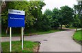
5
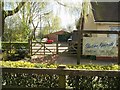
Entrance to East Claydon substation
A National Grid substation.
Image: © Robin Webster
Taken: 27 Mar 2015
0.04 miles
6
Entrance to National Grid East Claydon Substation, near East Claydon, Bucks
There is a public footpath running over part of the access road.
Image: © P L Chadwick
Taken: 20 Jul 2014
0.04 miles
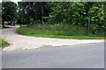
9
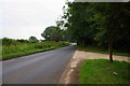
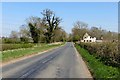
East Claydon Road near East Claydon, Bucks
The road is passing the entrance drive to the National Grid's East Claydon Substation. There is also a public footpath along part of the drive.
Image: © P L Chadwick
Taken: 20 Jul 2014
0.05 miles
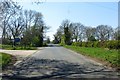
10
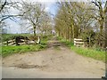
Farm Track
This farm track follows the course taken by an old railway line that linked Quainton Road station with Verney Junction.
Image: © Hywel Williams
Taken: 25 Mar 2005
0.06 miles