IMAGES TAKEN NEAR TO
Buckingham Road, BUCKINGHAM, MK18 3LZ
Introduction
This page details the photographs taken nearby to Buckingham Road, MK18 3LZ by members of the Geograph project.
The Geograph project started in 2005 with the aim of publishing, organising and preserving representative images for every square kilometre of Great Britain, Ireland and the Isle of Man.

There are currently over 7.5m images from over14,400 individuals and you can help contribute to the project by visiting https://www.geograph.org.uk
Image Map
Images are licensed for reuse under creativecommons.org/licenses/by-sa/2.0
Notes
- Clicking on the map will re-center to the selected point.
- The higher the marker number, the further away the image location is from the centre of the postcode.
Image Listing (5 Images Found)
Images are licensed for reuse under creativecommons.org/licenses/by-sa/2.0
Image
Details
Distance
1
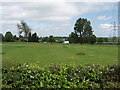
Pasture with track to Redfield community
The van is on the track to Redfield Community whose webpage http://www.lowimpact.org/redfieldcommunity.htm says "The environment is a high priority for the community - we have organic gardens and orchards; free-range animals; solar hot water; compost toilets; straw-bale buildings; we recycle and compost our waste; plant trees; and heat our rooms with wood-burning stoves. Perhaps more importantly though, we share resources - vehicles, workshops, laundry, and one kitchen". View from A413 road.
Image: © David Hawgood
Taken: 18 May 2007
0.07 miles
2
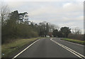
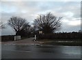
A413 towards Buckingham
Leaving Winslow.
Image: © Robin Webster
Taken: 22 Mar 2020
0.16 miles
3
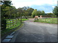
The entrance to Hanover Farm, Addington
Image: © David Howard
Taken: 4 Feb 2018
0.19 miles