IMAGES TAKEN NEAR TO
Lake Close, BUCKINGHAM, MK18 3LS
Introduction
This page details the photographs taken nearby to Lake Close, MK18 3LS by members of the Geograph project.
The Geograph project started in 2005 with the aim of publishing, organising and preserving representative images for every square kilometre of Great Britain, Ireland and the Isle of Man.

There are currently over 7.5m images from over14,400 individuals and you can help contribute to the project by visiting https://www.geograph.org.uk
Image Map
Images are licensed for reuse under creativecommons.org/licenses/by-sa/2.0
Notes
- Clicking on the map will re-center to the selected point.
- The higher the marker number, the further away the image location is from the centre of the postcode.
Image Listing (13 Images Found)
Images are licensed for reuse under creativecommons.org/licenses/by-sa/2.0
Image
Details
Distance
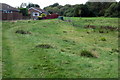
3
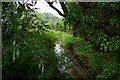
Stream just north of Winslow, Bucks
This is one of a number of small streams which encircle the town of Winslow. All of them eventually discharge into the River Ouse. Photographed from the Little Horwood to Winslow road, just north of Winslow.
The view in the opposite direction:- Image
Image: © P L Chadwick
Taken: 20 Jul 2014
0.08 miles
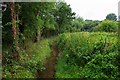
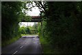
4
Road from Little Horwood crossing a stream just north of Winslow, Bucks
The railings on each side of this minor road indicate where the stream passes under the road.
Image
Image: © P L Chadwick
Taken: 20 Jul 2014
0.09 miles
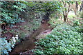
5
Stream just north of Winslow, Bucks
This is one of a number of small streams which encircle the town of Winslow. All of them eventually discharge into the River Ouse. Photographed from the Little Horwood to Winslow road, just north of Winslow.
The view in the opposite direction:- Image
Image: © P L Chadwick
Taken: 20 Jul 2014
0.09 miles
6
Disused Railway Bridge
Rail bridge carrying the old Bletchley to Oxford line just north of Winslow.
Image: © Mr Biz
Taken: 26 Sep 2011
0.14 miles
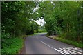
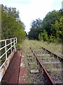
7
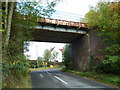
Disused railway bridge near Winslow, Bucks
The bridge carries a disused section of the former Oxford to Bletchley railway line across the minor road from Little Horwood, just north of Winslow. Funding is now in place to re-open this line and the Oxford to Bletchley section is due to re-open by 2019. It is likely it will be electrified. The section from Bletchley to Bedford is due to re-open in the period 2019-2024, and this is also expected to be electrified.
Image: © P L Chadwick
Taken: 20 Jul 2014
0.14 miles
8
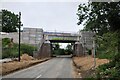
Rebuilt bridge over Horwood Road
The newly rebuilt railway bridge over Horwood Road. The steel bridge deck has been replaced as part of re-opening the railway line as an express route between Milton Keynes, Bicester and Aylesbury.
Image: © Bob Walters
Taken: 24 Jun 2021
0.14 miles
10

Open land at the back of The Spinney
Image: © Steve Daniels
Taken: 21 Apr 2015
0.20 miles