IMAGES TAKEN NEAR TO
Aylesbury Road, BUCKINGHAM, MK18 3LF
Introduction
This page details the photographs taken nearby to Aylesbury Road, MK18 3LF by members of the Geograph project.
The Geograph project started in 2005 with the aim of publishing, organising and preserving representative images for every square kilometre of Great Britain, Ireland and the Isle of Man.

There are currently over 7.5m images from over14,400 individuals and you can help contribute to the project by visiting https://www.geograph.org.uk
Image Map
Images are licensed for reuse under creativecommons.org/licenses/by-sa/2.0
Notes
- Clicking on the map will re-center to the selected point.
- The higher the marker number, the further away the image location is from the centre of the postcode.
Image Listing (8 Images Found)
Images are licensed for reuse under creativecommons.org/licenses/by-sa/2.0
Image
Details
Distance
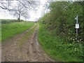
1
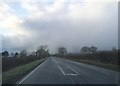
A413 Bennett's Hill
Towards Buckingham.
Image: © Robin Webster
Taken: 9 Jun 2019
0.14 miles
2
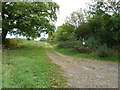
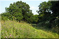
Swans Midshires Way Long Distance Footpaths
Running to the east of Granborough, both the Swans and Midshires Way footpaths run along the same track in this photo. This shot is looking back towards Swanbourne.
Image: © Mr Biz
Taken: 26 Sep 2011
0.19 miles
4
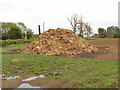
Dung heap
Maybe more farmyard straw than dung, but good stuff. In a field at the junction of the A413 and road to Granborough.
Image: © David Hawgood
Taken: 12 May 2007
0.21 miles
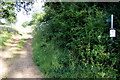
5
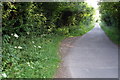
Swan's Way
Swan's Way leaves the road heading past Christmas Gorse
Image: © Shaun Ferguson
Taken: 2 May 2014
0.22 miles