IMAGES TAKEN NEAR TO
Quainton Road, BUCKINGHAM, MK18 3JZ
Introduction
This page details the photographs taken nearby to Quainton Road, MK18 3JZ by members of the Geograph project.
The Geograph project started in 2005 with the aim of publishing, organising and preserving representative images for every square kilometre of Great Britain, Ireland and the Isle of Man.

There are currently over 7.5m images from over14,400 individuals and you can help contribute to the project by visiting https://www.geograph.org.uk
Image Map
Images are licensed for reuse under creativecommons.org/licenses/by-sa/2.0
Notes
- Clicking on the map will re-center to the selected point.
- The higher the marker number, the further away the image location is from the centre of the postcode.
Image Listing (5 Images Found)
Images are licensed for reuse under creativecommons.org/licenses/by-sa/2.0
Image
Details
Distance
1
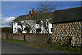
Stonehill Farm, Quainton Road, North Marston
The structure on the right is built with the local Portland Limestone.
Image: © David Kemp
Taken: 11 Feb 2022
0.03 miles
2
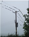
The birds !!!
Starlings gather on electric power lines near Steart Farm.
Image: © Rob Farrow
Taken: 13 Oct 2006
0.05 miles
3
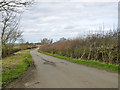
Carter's Lane
This is a slightly distorted Roman road.
Image: © Robin Webster
Taken: 27 Mar 2015
0.12 miles
4
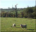
Sheep south of Midshires Way
A section of the Midshires Way runs along the route of the lane from Stonehill to Fulbrook Farms at this point. These sheep were grazing contentedly in a field to the south, with an old bare tree behind, and in the distance the telecoms mast at SP750213 on Image
Image: © Rob Farrow
Taken: 6 Nov 2007
0.16 miles
5
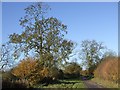
Lane from Stonehill Farm to Fulbrook Farm
This narrow lane has the Midshires Way running along its route at this point. It is a narrow lane, much used by horses, judging by the deposits ! A little further along it is gated as it crosses a wide sheep pasture.
Image: © Rob Farrow
Taken: 6 Nov 2007
0.19 miles