IMAGES TAKEN NEAR TO
North Marston, BUCKINGHAM, MK18 3GY
Introduction
This page details the photographs taken nearby to MK18 3GY by members of the Geograph project.
The Geograph project started in 2005 with the aim of publishing, organising and preserving representative images for every square kilometre of Great Britain, Ireland and the Isle of Man.

There are currently over 7.5m images from over14,400 individuals and you can help contribute to the project by visiting https://www.geograph.org.uk
Image Map
Images are licensed for reuse under creativecommons.org/licenses/by-sa/2.0
Notes
- Clicking on the map will re-center to the selected point.
- The higher the marker number, the further away the image location is from the centre of the postcode.
Image Listing (5 Images Found)
Images are licensed for reuse under creativecommons.org/licenses/by-sa/2.0
Image
Details
Distance
1
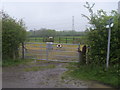
Path to North Marston
Path to North Marston by Hill View Paddocks
Image: © Shaun Ferguson
Taken: 25 Apr 2014
0.03 miles
2
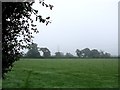
Fields off Carter's Lane
Looking northwest through a gap in the hedge on Carter's Lane. The National Grid is in evidence as is often the case !
Image: © Rob Farrow
Taken: 13 Oct 2006
0.16 miles
3
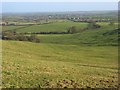
Pastures, Quainton
A valley descending northeast from Quainton Hill. Looking towards North Marston.
Image: © Andrew Smith
Taken: 5 Jan 2008
0.18 miles
4
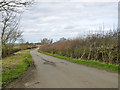
Carter's Lane
This is a slightly distorted Roman road.
Image: © Robin Webster
Taken: 27 Mar 2015
0.19 miles
5
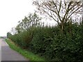
Carter's Lane near Woad Hill
Carter's Lane is an old Roman Road running roughly NNW/SSE through this part of Buckinghamshire. It is surrounded by farmland with scattered small villages and hamlets.
Image: © Rob Farrow
Taken: 13 Oct 2006
0.20 miles