IMAGES TAKEN NEAR TO
Beamish Way, BUCKINGHAM, MK18 3EU
Introduction
This page details the photographs taken nearby to Beamish Way, MK18 3EU by members of the Geograph project.
The Geograph project started in 2005 with the aim of publishing, organising and preserving representative images for every square kilometre of Great Britain, Ireland and the Isle of Man.

There are currently over 7.5m images from over14,400 individuals and you can help contribute to the project by visiting https://www.geograph.org.uk
Image Map
Images are licensed for reuse under creativecommons.org/licenses/by-sa/2.0
Notes
- Clicking on the map will re-center to the selected point.
- The higher the marker number, the further away the image location is from the centre of the postcode.
Image Listing (3 Images Found)
Images are licensed for reuse under creativecommons.org/licenses/by-sa/2.0
Image
Details
Distance
1
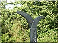
Millennium milepost on NCN51 at Winslow (closeup)
See Image for a wider view.
Image: © Colin Bell
Taken: 15 Jul 2009
0.20 miles
2

Millennium milepost on NCN51 at Winslow
The west of a set of three along the cyclepath between Winslow and Bletchley. See Image for the next one east. The route enters Winslow from the east through a recreation ground.
Image is a closeup of the post.
Image: © Colin Bell
Taken: 15 Jul 2009
0.21 miles