IMAGES TAKEN NEAR TO
High Street, BUCKINGHAM, MK18 3DN
Introduction
This page details the photographs taken nearby to High Street, MK18 3DN by members of the Geograph project.
The Geograph project started in 2005 with the aim of publishing, organising and preserving representative images for every square kilometre of Great Britain, Ireland and the Isle of Man.

There are currently over 7.5m images from over14,400 individuals and you can help contribute to the project by visiting https://www.geograph.org.uk
Image Map
Images are licensed for reuse under creativecommons.org/licenses/by-sa/2.0
Notes
- Clicking on the map will re-center to the selected point.
- The higher the marker number, the further away the image location is from the centre of the postcode.
Image Listing (45 Images Found)
Images are licensed for reuse under creativecommons.org/licenses/by-sa/2.0
Image
Details
Distance
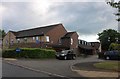
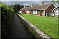
3
Shaftesbury Court care home, Winslow
A care home run by Sanctuary Care, see http://www.sanctuary-housing.co.uk/Sanctuary+Care/.
Image: © David Hawgood
Taken: 18 May 2007
0.06 miles
4
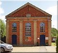
Winslow Baptist Tabernacle
Brick built in classical style. Just off the High Street (and just on a grid line). The plaque above the pillars reads "Tabernacle 1864". The chapel has a website http://www.winslowbaptistchurch.org.uk/ with a substantial history http://www.winslowbaptistchurch.org.uk/Edited%20Church%20History.pdf (pdf file). This includes an account of the predecessor chapel by the cattle market, and details and photos of the pastors.
Image: © David Hawgood
Taken: 18 May 2007
0.06 miles
5
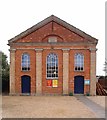
Winslow Tabernacle
Built in 1864, the Winslow Tabernacle is home to an evangelical Christian church.
Image: © Jim Osley
Taken: 11 Aug 2015
0.06 miles
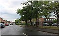
7
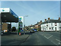
High Street/Station Road junction, Winslow
Image: © Colin Pyle
Taken: 29 Feb 2016
0.08 miles
8
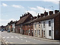
High Street, Winslow
Houses and small shops, all two storey but with a variety of heights and roof lines.
Image: © David Hawgood
Taken: 18 May 2007
0.08 miles
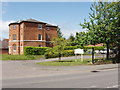
9
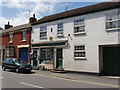
Ironmonger's shop, Winslow High Street
It looks a very small shop but presumably the archway at the right of the photo gives access to a yard and outbuildings.
Image: © David Hawgood
Taken: 18 May 2007
0.08 miles
10
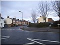
High Street at the junction of Station Road, Winslow
The railway line was on the Oxford to Cambridge Varsity Line route but was disused many decades ago. The section from Oxford to Bicester was reopened in the 90s but had already been used for freight since its closure to passengers. The Bletchley to Bedford stretch was the only part to be retained on the initial closure. https://en.wikipedia.org/wiki/Varsity_Line
Image: © David Howard
Taken: 4 Feb 2018
0.09 miles